
No hay productos en el carrito.


Recomendable 100%. Destacar el trato cercano y su preocupación por los pequeños detalles. Seguiremos contando con ellos.

He quedado encantado con la atención y el resultado. Han sabido entender y plasmar perfectamente mis necesidades.

Sin duda un gran acierto. Nos decidimos por Topocomponentes por recomendación de otro cliente y repetiremos.

Muy contento con el servicio. El pedido lo recibí antes de lo esperado. Es la primera vez que he comprado en esta tienda online y no será la última vez. Muchas gracias

Muy buen servicio de entrega cumplen lo dicho y esto es muy gratificante. Excelente.

Rapida entrega y precios inmejorables. Muy satiafecho. Sin duda volveré a comprar.

Me ha encantado la rapidez y el servicio. Muy buena atención.
GNSS de Alto Poder en cualquier momento y en cualquier lugar
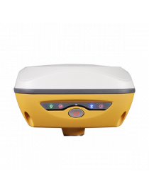
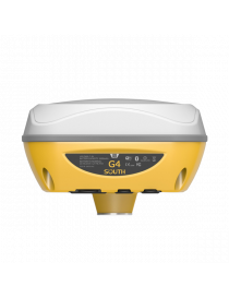
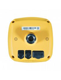
South ha rediseñado el receptor, incorporando una llamativa carrocería amarilla basada en los comentarios de los usuarios para mejorar la visibilidad de los topógrafos y los instrumentos en diversos entornos. Ya sea en una obra de construcción o en bosques densos, la visibilidad mejorada de los usuarios del G4 promueve la seguridad. En condiciones difíciles como bosques o de noche, el estado de funcionamiento del receptor ahora es más claramente visible desde la distancia. Las tecnologías avanzadas del equipo de investigación SOUTH, como el algoritmo SOUTH, garantizan una corrección precisa de los datos en entornos hostiles. La función de mantenimiento fijo permite una medición continua durante unos minutos después de perder la solución fija. Aprovechando Beidou PPP y Galileo HAS, su tecnología permite un posicionamiento preciso de puntos a través de señales satelitales, incluso en áreas sin corrección CORS.
Canales: 1698
Sensor de inclinación IMU: 60 °
Módem de Internet: 4G
Radio UHF: 410 – 470MHz
GPS: L1, L1C, L2C, L2P, L5
GLONASS: G1,G2,G3
GALILEO: E1, E5A, E5B, E6C
BEIDOU: B1I, B2I, B3I , B1C, B2A, B2B
| GNSS Features | Channels | 1698 |
| GPS | L1, L1C, L2C, L2P, L5 | |
| GLONASS | G1,G2,G3 | |
| BDS | B1I,B2I,B3L,B1C,B2A,B2B* | |
| GALILEO | E1,E5A,E5B,E6C* | |
| SBAS | L1C,L1A* | |
| NavIC/ IRNSS | L5* | |
| QZSS MSSL - Band(Reserve) |
L1,L2C,L5* | |
| Positioning output rate | 1Hz~20Hz | |
| Initialization time | < 10s | |
| Initialization reliability | >99.99% | |
| Positioning Precision | Code differential GNSS | Horizontal: 0.25 m + 1 ppm RMS Vertical: 0.50 m + 1 ppm RMS |
| Static(long observations) | Horizontal: 2.5 mm + 0.1 ppm RMS Vertical: 3 mm + 0.4 ppm RMS |
|
| Static | Horizontal: 2.5 mm + 0.5 ppm RMS Vertical: 3.5 mm + 0.5 ppm RMS |
|
| Rapid static | Horizontal: 2.5 mm + 0.5 ppm RMS Vertical: 5 mm + 0.5 ppm RMS |
|
| PPK | Horizontal: 3 mm + 1 ppm RMS Vertical: 5 mm + 1 ppm RMS |
|
| RTK(UHF) | Horizontal: 8 mm + 1 ppm RMS Vertical: 15 mm + 1 ppm RMS |
|
| RTK(NTRIP) | Horizontal: 8 mm + 0.5 ppm RMS Vertical: 15 mm + 0.5 ppm RMS |
|
| RTK initialization time | 2 ~ 8s | |
| SBAS positioning | Typically < 5m 3DRMS | |
| BANDA-L | Horizontal: 5-10cm (5-30min) Vertical: 10-30cm (5-30min) |
|
| IMU | Less than 10mm + 0.7 mm/° tilt to 30° | |
| IMU tilt angle | 0° ~ 60° | |
| Hardware Performance | Dimension | 135mm(W)×135mm(L)×84.75mm(H) |
| Weight | 890g(battery included) | |
| Material | Magnesium aluminum alloy shell | |
| Operating temperature | -25℃~+65℃ | |
| Storage temperature | -35℃~+80℃ | |
| Humidity | 100% Non-condensing | |
| Waterproof/Dustproof | IP68 | |
| Shock/Vibration | MIL-STD-810G(withstand 2meters pole drop onto the cement ground naturally) | |
| Power supply | 6-28V DC, over voltage protection | |
| Battery | Inbuilt 7.4V 6800mAh rechargeable Li-ion battery | |
| Battery life | Typically 20h(static), 7h(Base+UHF) 1 9h(Rover+UHF), 20h(Rover+Bluetooth) | |
| Communications | I/O Port | 5-PIN LEMO external power port + RS232 Type-C(charge+USB+OTG+Ethernet) 1 UHF antenna interface |
| Internal UHF | 2W Radio receiver and transmitter | |
| Frequency range | 410-470MHz | |
| Communication protocol | Farlink, Trimtalk, SOUTH, HUACE, Hi-target, Satel | |
| Communication range | Typically 5km with Farlink protocol, up to 12km | |
| Bluetooth | Bluetooth3.0/4.1standard,Bluetooth2.1+EDR | |
| NFC Communication | Realizing close range (shorter than 10cm) automatic pair between receiver and controller(controller requires NFC wireless communication module else) | |
| Cellular | 4G | |
| WIFI | Modem | 802.11 b/g standard |
| WIFI hot spot | Receiver broadcasts its hot spot form web UI accessing with any mobile terminals | |
| WIFI datalink | Receiver can transmit and receive correction data stream via WiFi datalink | |
| Data Storage/Transmission | Storage | 4GB SSD internal storage standard, extendable up to 128GB Automatic cycle storage(The earliest data files will be removed automatically while the memory is not enough) Support external USB storage The customizable sample interval is up to 20Hz |
| Data transmission | Plug and play mode of USB data transmission Supports FTP/HTTP data download |
|
| Data format | Static data format:STH,Rinex2.01,Rinex3.02,etc. Differential data format:CMR,CMR+,RTCM2.1, RTCM2.3,RTCM3.0,RTCM3.1,RTCM3.2(recommended) GPS out put data format:NMEA0183,PJK plane coordinate,Binary code Network model support:VRS,FKP,MAC,Fully support NTRIP protocol |
|
| Sensors | Electronic bubble | Controller software can display electronic bubble, checking leveling status of the carbon pole in real-time |
| IMU | Built-in IMU module, calibration-free and immue to magnetic interference | |
| Thermometer | Built-in thermometer sensor, adopting intelligent temperature control technology, monitoring and adjusting the receiver temperature | |
| User Interaction | Operating system | Linux |
| Buttons | Single button | |
| Indicators | 4LED indicators | |
| Web interaction | With the access of the internal web interface management via WiFi or USB connection, users are able to monitor the receiver status and change the configurations freely |
|
| Voice guidance | It provides status and operation voice guidance, and supports Chinese/English/Korean/Spanish/Portuguese/Russian/Turkish | |
| Secondary development | Provides secondary development package, and opens the OpenSIC observation data format and interaction interface definition | |
| Cloud service | The powerful cloud platform provides online services like remote manage, firmware update, online register and etc |
*Reserve for future upgrade. Remarks: Measurement accuracy and operation range might vary due to atmospheric conditions, signal multipath, obstructions, observation time, temperature, signal geometry, correction format used and number of tracked satellites. Specifications subject to change without prior notice

GNSS de Alto Poder en cualquier momento y en cualquier lugar